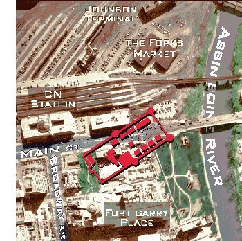
Aerial View Showing the Outline of the Fort Overlaid on the Present City
Since the Gate is surrounded and overshadowed by buildings, it is difficult to step back and get any bearing on the size of the fort and the direction it lay. Therefore, this map attempts to approximate the size and direction of the fort according to the information gathered. This is not meant to be an archeological treatise on Upper Fort Garry and as such the map may be off by a bit here or there. It is however, meant to provide the viewer with a better understanding of an important part of our history by linking what remains to the grandeur of what once existed. Note: this aerial map predates The Forks Market by several years, but the location of the market is indicated (as shown by the original buildings) merely to help orientate the viewer.
Even with the Hudson's Bay Company's domniance broken, many years of pent up resentment towards the company's years of monopoly continued. The gulf further widened between the people of Winnipeg and the Company when the Company opposed the incorporation of the city. By this time the settlement grew and property became an important commodity. The Company divided its Fort Garry Reserves (some of the best property available) into lots. The land the fort rested on became more valuable than the fort itself and since it no longer represented the seat of power in the area, it was abandoned by 1882 and quickly fell into disrepair. Part of the walls were later removed to straighten Main Street and the only occupant of some of the buildings of the fort was the Winnipeg Street Car Company.
|
 The
most common held notion that most people have for the dismantling of the
fort, was the desire to straighten Main Street. However, the fate of the
fort had long been sealed before any consideration was given to straightening
Main Street. In the 1850's as Winnipeg began to grow and purposely develop
northward away from the fort, The Hudson's Bay Company was perceived to
be more interested in profit than creating settlements. This was seen as
a barrier to further development of the city. Attempts were made to break
the Company's monopoly which culminated in the purchase of Ruperts Land
from the Company in 1870, ending the Company's monopoly, Charter and a
historic era.
The
most common held notion that most people have for the dismantling of the
fort, was the desire to straighten Main Street. However, the fate of the
fort had long been sealed before any consideration was given to straightening
Main Street. In the 1850's as Winnipeg began to grow and purposely develop
northward away from the fort, The Hudson's Bay Company was perceived to
be more interested in profit than creating settlements. This was seen as
a barrier to further development of the city. Attempts were made to break
the Company's monopoly which culminated in the purchase of Ruperts Land
from the Company in 1870, ending the Company's monopoly, Charter and a
historic era. 
