A Clickable Map
To Help You Around The Fort
 he
original photographic images used throughout this presentation range in
dates from the early 1870's to the middle 1880's. These are by no means
all the photographs that exist on the fort. Both The Provincial Archives
and the Hudson's Bay Company Archives contain more photographs, some are
dated as far back as the 1850's. The images chosen provide an interesting
overview of the fort and in particular, show how quickly the fort degenerated
when it no longer was considered valuable. he
original photographic images used throughout this presentation range in
dates from the early 1870's to the middle 1880's. These are by no means
all the photographs that exist on the fort. Both The Provincial Archives
and the Hudson's Bay Company Archives contain more photographs, some are
dated as far back as the 1850's. The images chosen provide an interesting
overview of the fort and in particular, show how quickly the fort degenerated
when it no longer was considered valuable.
|
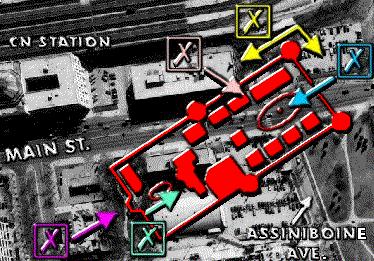
The
clickable map shows a close up view of the aerial map. To use this map
click on any X with your mouse. The colour
of the X corresponds to the coloured
arrows which in turn shows the part of the fort that will be displayed. |
 To
the Aerial View of the city To
the Aerial View of the city
 Back
to the Beginning Back
to the Beginning
|