A Short Pictorial History On Upper Ft. Garry
Upper Fort Garry was the last of five forts, known to have been built in this general vicinity. The other forts included: Fort Rouge (circa 1736), Fort Gibraltar (circa 1806), Fort Douglas (circa 1815) and the original Fort Garry (circa 1821). After the flood of 1826 when the original Fort Garry was demolished, Govenor George Simpson (later to be Governor of Ruperts Land), for politcal reasons, decided to rebuild the fort downstream and in 1831 built Lower Fort Garry at its present location near Selkirk, Manitoba. The move was unpopular because the majority of trade was already established at "the forks" and it required at least a day's journey to Lower Fort Garry. So the Hudson's Bay Company decided to returned to the forks, which was the centre of trade and built a second fort. This new fort built in 1835, was named Upper Fort Garry to distinguish it from Lower Fort Garry. With its four large bastions and formidable 15 foot high stone walls its presence was meant to demonstrate the Company's dominant role in the area. Both forts were named after Nicholas Garry, an important director of the Hudson's Bay Company, who assisted in the amalgamation of the HBC and the North West Company.
The traffic between the two forts was considerable. To traverse this trail, the ox carts would travel 20 side by side, rather than in a long single file. This was to distribute the weight of the carts and avoid very deep ruts which was a problem with the soft earth of the area. This left a wide road of about 120 feet. As the city of Winnipeg developed, this trail known then as Garry Street would eventualy be paved over, maintaining its original width. Of course we know it better as Main Street. To continue the journey:
Note: Some of the images were originally in poor condition and required extensive image enhancement, e.g. removing blemishes, creating contrast, sharpening and pixel editing. Regardless of what type of image editing was required, or how the image was cropped to fit in a particular space, the basic image integrity was not compromised, except for what's stated in the following paragraph. To help relate the past to the present, some of the images have been colourized. Yes, skies were actually blue, and flowers had colour, even in the old days. Unfortunately, we are use to seeing historical photographs in black and white and forget that the colours we see outside were the same colours seen in the past. Hopefully the colourized photographs will help relate the past to the present.
Original photographic material from: Provincial Archives 200 Vaughan St., Winnipeg, MB., R3C 1T5 (204) 945-3971 Original aerial map from: Department of Natural Resources Land Information Centre 1007 Century St., Winnipeg, MB., R3H 0W4 (204) 945-6666 This page is a production of Lincoln Park Gallery. Enquiries, Ideas, Thoughts? E-mail : info@lpgallery.mb.ca |
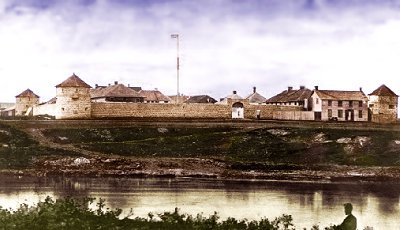 This view shows the south end, the original part of the fort
as seen from across the Assiniboine River. This photograph (circa 1878)
probably the most famous one of Upper Fort Garry, gives a good indication
of how impressive this structure was. Among the buildings enclosed by the
fort were the barracks, officers quarters, Chief Factors residence, general
store, fur store, Governor's residence and pemmican store. The building
in the far right of the photograph, just outside the south wall is the
liquor store.
This view shows the south end, the original part of the fort
as seen from across the Assiniboine River. This photograph (circa 1878)
probably the most famous one of Upper Fort Garry, gives a good indication
of how impressive this structure was. Among the buildings enclosed by the
fort were the barracks, officers quarters, Chief Factors residence, general
store, fur store, Governor's residence and pemmican store. The building
in the far right of the photograph, just outside the south wall is the
liquor store.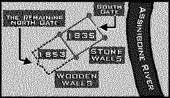 By
1853, the fort was proving to be too small for the increasing trade and
it was extended to the north. It was decided to forgo the expense of stone
in favour of wooden walls made of two rows of squared oak logs filled with
dirt. The North Gate, the only original remnant of the fort that has survived,
had parts of it's wooden walls restored about 20 years ago.
By
1853, the fort was proving to be too small for the increasing trade and
it was extended to the north. It was decided to forgo the expense of stone
in favour of wooden walls made of two rows of squared oak logs filled with
dirt. The North Gate, the only original remnant of the fort that has survived,
had parts of it's wooden walls restored about 20 years ago. To the Clickable Map
 To the Aerial View of the Fort Overlaid on the Present City